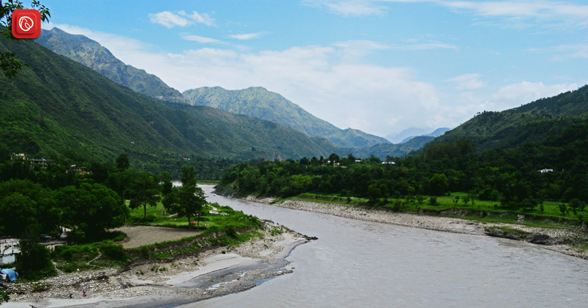
Located in South Asia, the river Sutlej is a crucial watercourse that winds its way through the terrains of India and Pakistan. Known as Zaradros to the ancient Greeks and Shutudri in Sanskrit, this river holds a rich historical significance in the region. It starts its journey in the Himalayas on the northern slope of South Western Tibet, playing a vital role in shaping the geography and supporting agriculture in both nations.
As it flows through the scenic Himalayan gorges, it enters the Indian region of Himachal Pradesh, where it merges with the Beas River near Nangal. In this blog Graana.com brings you a comprehensive guide to Sutlej river.
History & Background
The river Sutlej has a long history, dating back to ancient times. Its water flow and hydrology are influenced by monsoon rains and spring and summer snowmelt.
The river experiences significant flooding, particularly during the monsoon season from June to August, with the highest recorded flood release in 1955 at approximately 17,000 cubic metres per second, leading to costly downstream flooding. In the winter season, the water flow decreases due to minimal precipitation and the absence of meltwater from Himalayan glaciers.
Extending over about 1,400 km, the river Sutlej serves a crucial role in irrigation and farming. Given its shared importance to both Pakistan and India, a substantial water dispute emerged in the late 1950s. The Indus Water Treaty was eventually signed by both nations, resolving that India was granted water rights to the Sutlej River.
However, India was prohibited from storing or obstructing the water flow of the Indus River, which was allocated to Pakistan under the treaty. This agreement aimed to address the competing water needs of the two nations and establish a fair distribution of water resources.
Geography & Physical Characteristics
In the past, the region through which the river Sutlej flowed was referred to as the Garuda Valley, positioned just a short distance from the Himalayan ranges. During that era, the river, also known as the Zaradros River, played a crucial role as the primary means of transportation for both local communities and the royalty.
Villages such as Hamir, Pur, and Bilas relied on the river for the transportation of timber and firewood. In ancient religious beliefs, the river Sutlej held a divine status, regarded as a God.
However, with the Muslim invasion of the Indian Subcontinent, its name transitioned to “Ja-e-ilm”, signifying the “place of knowledge”. This transformation reflects the dynamic history and cultural shifts that have shaped the perception and nomenclature of the river over time.
Origin
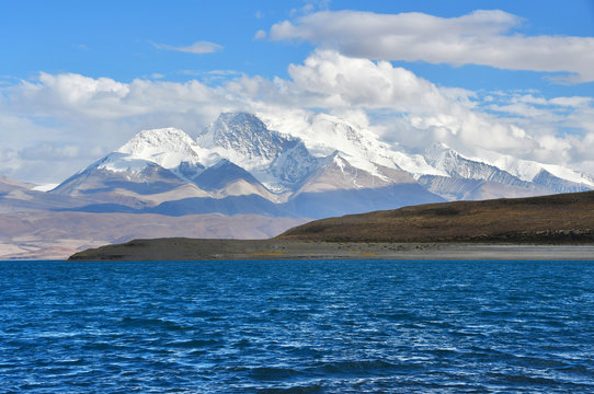
The Sutlej River, originating from Lake La’nga in southwestern Tibet at an elevation above 15,000 feet, embarks on a journey that traverses the rugged terrains of the Himalayas.
Flowing initially in a northwestward direction and then veering west-southwestward through the dramatic gorges of the Himalayas, this river charts a course that plays a crucial role in the geographic tapestry of the region.
River Sutlej Length
The source of the river Sutlej is situated 20,000 feet above the average sea level. This river is the easternmost branch of the river Indus, and its total length is 1450 km, with 529 km of its course passing through Pakistan.
The Ending Point of Sutlej River
Approximately 17 kilometres north of the shrine of Uch Sharif, the river Sutlej joins the river of Chenab. Eventually they fall into the river Indus at approximately 100 kilometres west of Bahawalpur. The Indus River runs down and falls into the Arabian Sea at the point of Port Bin Qasim.
Hydrology and Seasonal Dynamics
The hydrology of the Sutlej is intricately tied to the natural rhythms of the Himalayas and the South Asian monsoon.
Course through India
Upon entering the Indian subcontinent, the Sutlej courses through the state of Himachal Pradesh before reaching the expansive Punjab plain near Nangal in the Punjab state. Notably, it forms a significant segment of the India-Pakistan border, extending over 65 miles and receiving the waters of the river Beas along its course.
Confluence with Chenab River
As the river flows into Pakistan, it continues its journey for another 220 miles, ultimately merging with the Chenab River west of Bahawalpur. This confluence gives rise to the Panjnad, a pivotal juncture where the combined waters of the Sutlej and Chenab connect the Five Rivers with the mighty Indus.
Seasonal Dynamics
Controlled by the spring and summer snowmelt in the lofty Himalayan peaks, as well as the seasonal monsoon rains, the river experiences fluctuations in its flow throughout the year. Summer monsoons, in particular, bring heavy rains, often leading to downstream flooding.
The historical record notes a staggering maximum flood discharge of nearly 600,000 cubic feet per second in 1955, underscoring the river’s formidable force during such events.
Conversely, during the winter months, the flow of the Sutlej dwindles substantially. This reduction is attributed to minimal precipitation and the diminished contribution of meltwater from the Himalayan glaciers.
Role in Agriculture and Irrigation

The Sutlej is not merely a natural force but a vital resource for human activities in the region. Extensively harnessed for irrigation purposes, the river facilitates the cultivation of vast stretches of land, covering a length of 900 miles.
This reliance on the Sutlej’s waters has led to the implementation of major irrigation projects, with notable examples including the Bhakra-Nangal Project, the Sirhind Canal, and the Sutlej Valley Project. These projects span both India and Pakistan, underscoring the shared significance of the river for agricultural prosperity.
The river Sutlej is a lifeline for millions in Pakistan and holds a rich biodiversity, creating a diverse ecosystem as it flows through Punjab, Khyber Pakhtunkhwa, and Sindh.
Aquatic Life
The river provides a vital habitat for diverse aquatic species, hosting over 150 types of fish, various amphibians, and an array of invertebrates. The flowing waters and diverse habitats, from deep pools to shallow rapids, offer ideal breeding and feeding grounds for fish species such as mahseer, trout, and carp.
Amphibians like frogs and toads find shelter and breeding sites among the lush vegetation and rocky crevices. Invertebrates, including crabs, shrimps, and insects, play a crucial role in the river’s ecosystem, serving as food for fish and other aquatic organisms.
Wildlife Sanctuary
The riparian zones along the river Sutlej provide a haven for a wide range of terrestrial species. Lush vegetation, consisting of trees, shrubs, and grasses, offers food, shelter, and nesting sites for birds, mammals, and reptiles. More than 450 bird species, including migratory birds like ducks, geese, and herons, have been recorded along the river’s course.
Mammals such as otters, jackals, and wild boars depend on the river for food and water. Reptiles like turtles, snakes, and lizards also find suitable habitats along the river’s banks, creating a thriving wildlife sanctuary.
Threats and Conservation Efforts
Despite its ecological significance, the river Sutlej faces a multitude of environmental threats, including water pollution from agricultural runoff, industrial effluents, and sewage disposal. These pollutants can have detrimental effects on the river’s ecosystem, causing fish kills, algal blooms, and habitat degradation.
Dam construction and riverine sand mining have also disrupted the river’s natural flow and sedimentation patterns, further impacting aquatic and terrestrial life.
In recent years, there has been a growing recognition of the need to conserve the river Sutlej and its rich biodiversity. Conservation efforts have focused on pollution control, habitat restoration, and sustainable resource management.
The establishment of protected areas along the river’s course, such as the Keoladeo National Park and the Harike Wildlife Sanctuary, has played a crucial role in safeguarding the river’s ecosystem. Community-based conservation initiatives have also emerged, empowering local communities to protect their water resources and the natural heritage of the Sutlej River.
Historical Water Disputes and Diplomatic Resolution
However, the waters of the Sutlej were not always a source of cooperation between India and Pakistan. Prior to the Indus Waters Treaty of 1960, the river was a point of contention, with disputes over its usage.
The treaty marked a diplomatic milestone, allocating the Sutlej’s waters to India while granting exclusive Pakistani rights to the Indus and its western tributaries. This agreement brought a semblance of harmony to the region, acknowledging the river’s pivotal role in sustaining the livelihoods of people on both sides of the border.
Is the Sutlej a Tributary of the Indus?
The Sutlej stands as the most expansive among the five tributaries that contribute to the Indus River. Originating in Himachal Pradesh, it meanders through the east Punjab. Before making its way into Pakistan and ultimately merging with the Indus, the Sutlej converges with the Beas River. Remarkably, the Sutlej is the sole river in India that courses through Indian Punjab.
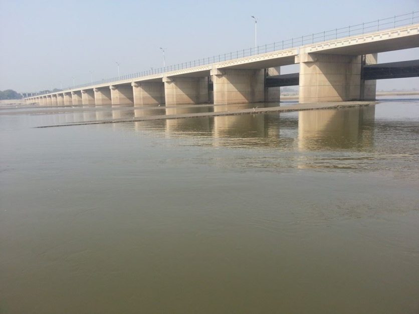
Headworks
Within Pakistan, two primary headworks govern the flow of the Sutlej River—the Islam Headwork and the Sulemanki Headwork. Notably, major dams are predominantly situated in India.
Islam Headwork
Functioning as a crucial digression point for the river Sutlej, the headwork Islam, also known as Head Islam, is strategically positioned at Hasilpur in Punjab.
Located approximately 15 km north of Hasilpur and 8 km along the Vehari-Hasilpur road, it serves as a central hub for flood control and the provision of irrigation water to farmers. With a design capacity to release 8500 cubic metres of water every second, the headwork Islam irrigates an extensive 278,800 hectares of area surrounding Bahawalpur.
Three major canals, namely the Bahawal Canal, Mailsi Canal, and Qaim Canal, stem from the headwork Islam, nourishing the surrounding agricultural landscapes.
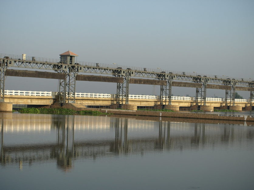
Sulemanki Headwork
Another vital structure along the river Sutlej is the Sulemanki Headwork, situated near Okara. This headwork, an integral part of the Sutlej Valley Project, was constructed collaboratively by the British government and the Nawab of Bahawalpur. Envisioned to enhance the development of barren areas, the irrigation project aimed to provide fresh water for both agricultural and domestic purposes.
Bahawalpur’s Landmark: Mailsi Syphon
Standing as a historic marker on the river of Sutlej, the Bahawalpur Head Syphon, officially known as Mailsi Syphon, marks the place where the link canal SMB passes beneath the Sutlej river. This engineering marvel, allowing approximately 6000 cusecs of water to flow beneath the riverbed. This played a pivotal role in the settlement plan of Indus Basin.
Bridges Spanning the Sutlej River
Numerous bridges, both large and small, grace the river Sutlej after its entry into Pakistan. Among them, the noteworthy railway bridge, constructed in 1826 during the era of Nawab of Bahawal Khan III, stands out. Originally a single-track passage, the bridge underwent significant upgrades in 1926. It transformed into a double-track marvel that strengthened the connection between the province of Sindh and Upper Punjab.
Recreational Oasis: Boating on the Sutlej
For those seeking recreational activities, the river Sutlej provides opportunities for boating and various water sports along its course.
Strategic Importance of the Sutlej
Originating in Himachal Pradesh, India, it flows south-westwards and west into the Shipki La Pass. There it reaches an altitude of 6608 metres. The river’s path extends north of the Vindhya ranges and east of Pakistan’s Makran range. Ultimately merges with the river Chenab.
Despite water allocations favouring India, the Sutlej plays a vital role for Pakistan. As it sustains multiple irrigation canals crucial for crop cultivation. Moreover, this canal system, enabled by the Sutlej’s waters, is indispensable for extensive farming. Other than that, the river contributes to environmental health, mitigating the impacts of global warming to a certain degree.
Fascinating Trivia about the Sutlej River
In Ancient Greek, it was known as Zaradros, and in Sanskrit, it was referred to as Shutudri. Many religions have revered the river as a deity.
The Sutlej River lends its name to the region of Punjab, meaning “Five Rivers.”
FAQs
Following are a few FAQs regarding Sutlej River:
Where does the river Sutlej originate, and what is its course in Pakistan?
The river originates in southwestern Tibet and flows through India and Pakistan. In Pakistan, it enters from the north, covering approximately 220 miles before merging with the Chenab River.
What is the length of the river Sutlej in Pakistan, and how does it contribute to agriculture?
The river Sutlej is about 220 miles long in Pakistan, supporting over 900 miles of cultivated land. It contributes significantly to agricultural prosperity through projects like Bhakra-Nangal and Sutlej Valley.
What are the major environmental threats faced by the river Sutlej ecosystem?
The river Sutlej ecosystem faces threats such as pollution, habitat degradation, and climate change impacts, jeopardising aquatic and terrestrial species. Conservation efforts are crucial for sustainable management.
What are some key infrastructure developments along the river Sutlej in Pakistan?
Two primary headworks, Islam Headwork and Sulemanki Headwork, govern the river Sutlej in Pakistan. The Islam Headwork, located in Punjab, aids flood control and irrigation. Major dams are primarily in India, contributing to the river’s management.
This was all about Sutlej River. For more information on other similar topics, visit Graana.com.