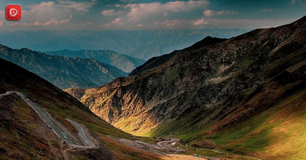
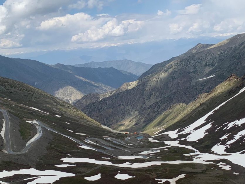
The Babusar Top has breathtaking views of scattered plateaus, green meadows, fast-flowing streams, and the peaks of Kashmir covered in snow. This area is a captivating spectacle for tourists, transforming each journey into a unique and unforgettable experience. The twisting roads leading to Babusar Pass feature sharp, steep bends, and offer breathtaking scenery on both sides.
Babusar Pass is a sought-after summer destination for outdoor enthusiasts, thanks to its rich biodiversity. The nearby pine and oak forests are home to various bird species, including snow cocks, owls, hawks, and pigeons.
The region boasts an abundance of sheep and wild goats. However, farming is quite challenging here due to the harsh climate and high altitude.
Graana.com discusses everything you need to know about Babusar Pass, including its history, geography, weather and more.
Overview
| Aspect | Details |
|---|---|
| Location | Between Kaghan Valley (Khyber Pakhtunkhwa) and Chilas (Gilgit-Baltistan) |
| Altitude | Approximately 4,173 meters (13,691 feet) |
| Accessibility | Accessible by road (Kaghan Valley side) |
| Seasonal Access | Typically open from late June to early November, depending on weather conditions |
| Scenery | Offers breathtaking views of snow-capped peaks, glaciers, and lush valleys |
| Activities | Photography, sightseeing, enjoying mountain landscapes |
| Nearby Attractions | Nanga Parbat (9th highest mountain in the world), Lulusar Lake, Dudipatsar Lake |
History of Babusar Pass
The name “Babusar Top” has historical significance as it was originally known as “Babur Top” in the early 16th century, attributed to the frequent travels of the Mughal emperor Babur through this region.
Before the construction of the all-weather Karakoram Highway (KKH), Babusar Top is a crucial part of the traditional summer route connecting the Kaghan Valley to the Gilgit-Baltistan region. The route remained in use from 1947 until 1978 when the KKH was officially opened for regular transportation. The British initially constructed this route in 1890 to establish a connection between Gilgit-Baltistan and British India.
In the pre-partition era, travellers from India and Kashmir used to journey to Gilgit-Baltistan via the Babusar Pass. Another caravan route, the Burzil Pass (elevated at 4,100 metres), connected Srinagar to Gilgit through Astore. Most of the Kaghan Valley is separated from the Neelum Valley of Azad Kashmir by a mountain range.
These historical details shed light on the significance of Babusar Top and the routes that have facilitated travel through this region over the centuries.
Geography
The Mansehra District is marked by the extensions of the vast Himalayan mountain system, which enters the region from Kashmir. The Kaghan Valley, situated in this district, hosts the highest mountain range in the area, including the renowned Babusar Top. Within this range, you’ll find Malika Parbat, the valley’s tallest peak, soaring to nearly 17,000 feet and located along the right bank of the Kunhar River.
During the summer months, Gujjars and other nomadic communities migrate to the mountain grasslands to graze their livestock, including sheep and goats. To the north, you’ll encounter mountain ranges that are connected to the Kaghan mountains.
At Musa ka Musalla, a peak with an elevation of approximately 13,500 feet, this range diverges from the eastern side, running along the northern boundaries of the Bhogarmang and Konsh valleys and sending down a spur that separates the two.
Much like Kaghan Valley, these mountains are naturally adorned with dense forests, particularly on their upper slopes. However, extensive deforestation has led to the prevalence of dense woods primarily in remote, less-explored areas.
Accessibility
Babusar Pass is not only scenic but also one of the most convenient routes to get to Gilgit Baltistan. However, it’s essential to note that this route is open and accessible for a limited duration due to the unpredictable weather conditions in the region.
Starting your journey from Islamabad, you can follow the route that takes you through Abbottabad, Mansehra, and Balakot. Alternatively, there’s a shorter option that leads over the picturesque Murree Hills to Muzaffarabad and continues through Gari Habibullah to Balakot.
Naran is a popular stopover destination along the way, offering a convenient place for overnight stays. It’s approximately a 6-hour drive from Islamabad and a 5-hour drive from Gilgit.
Pro Tip: It’s advisable to check the visiting times set by the Babusar Top administration before embarking on your journey to ensure a smooth and enjoyable experience.
Tourism
A journey from Naran to Babusar Top is nothing short of captivating. Along the way, travellers are treated to a plethora of breathtaking sights, including snow-capped peaks that form the backdrop to vast valleys, lively streams, lush and dense forests, picturesque meadows, and green terraced fields. These scenic wonders beckon visitors to pause and savour the moments during their ascent. A tranquil gem known as Lulusar Lake provides the perfect spot for a brief stopover.
Babusar Top stands as a must-visit destination that draws throngs of tourists, both from around the world and the local region. It’s a place that consistently buzzes with the excitement of eager travellers. Whether you’re en route to Gilgit Baltistan or embarking on a day trip from Naran, Babusar Top offers a beautiful respite, inviting you to linger, savour a meal, and explore its natural wonders.
Route to Babusar Pass
Being the highest point of Kaghan Valley, located in the Mansehra District, this pass links the valley to Chillas via the Karakoram Highway and Thak Nala. It is also famous as one of the busiest hairpin routes in the world.
The road leading to Babusar Pass has recently undergone renovations to improve its condition. It’s important to note that there are limited amenities available along the way, so it’s advisable to bring your own food and essential supplies.
Babusar Pass is situated approximately 80 kilometres from Naran. During your journey to the pass, you’ll be treated to the breathtaking beauty of the Kaghan Valley. Along the route, you can explore attractions such as the Lalazar Plateau, Dudipatsar Lake, and Lulusar Lake, which happens to be the largest natural lake in Hazara. Batakundi is another point of interest, just 16 kilometres from Naran.
The road to Babusar Pass is in good condition and can accommodate various types of vehicles. It has gained popularity as a tourist destination due to its proximity to many attractions. It’s worth noting that some parts of the road leading to the pass might experience temporary blockages due to severe weather conditions, but these obstacles are typically cleared by road maintenance crews when the summer thaw occurs.
Weather at Babusar Top
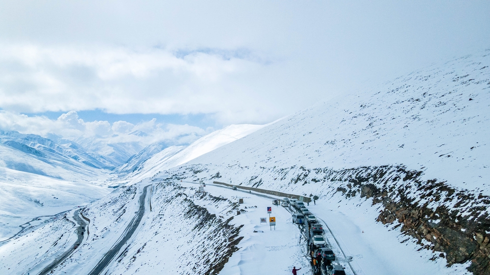
The ideal time to explore Babusar Top is during the summer months, spanning from May to September. In May, the temperature typically ranges between 11°C (52°F) at its highest and 3°C (37°F) at its lowest. The route to Babusar Pass remains accessible from mid-July through the end of September, extending your window for exploration.
However, it’s important to note that travel is restricted during the monsoon and winter seasons. If you’re planning a trip to the Kaghan region, you can reach it via routes from Islamabad or Peshawar.
Best Time for Visiting Babusar Pass
The most favourable period to explore Babusar Top falls between May and September, which coincides with the year’s warmer months. During the colder months, the pass becomes inaccessible as it is temporarily shut down due to heavy Babusar top snowfall and extreme weather conditions.
Naran to Babusar Top distance is approximately 75 kilometers (about 47 miles) via the Naran-Babusar Road. So, if you are travelling to Naran, do not forget to visit Babusar Pass.
Frequently Asked Questions (FAQs)
What is Babusar Pass?
Babusar Pass is a high-altitude mountain pass located in the Kaghan Valley of Pakistan. It is a crucial route connecting the Kaghan Valley to Gilgit-Baltistan and is renowned for its stunning natural beauty.
What is the Distance from Islamabad to Babusar Top?
Islamabad to Babusar top distance is 6 hr 53 min (349.5 km) via Hazara Motorway/M-15 and N-15.
When is the best time to visit Babusar Pass?
The best time to visit Babusar Pass is during the summer months, from May to September. During this period, the weather is relatively mild, and the pass is accessible to tourists.
Is Babusar Pass open year-round?
Babusar Pass is not open year-round. It is typically open to traffic from mid-July through the end of September. Access to the pass is restricted during the monsoon and winter seasons due to challenging weather conditions.
What are some nearby attractions to Babusar Pass?
The Kaghan Valley offers several nearby attractions, including the Lalazar Plateau, Dudipatsar Lake, and Lulusar Lake, the largest natural lake in Hazara. These natural wonders make for excellent side trips when visiting Babusar Pass.
Are there any facilities or amenities available at Babusar Pass?
Babusar Pass does not have extensive facilities or amenities. Travellers are advised to bring their own food and essential supplies. It’s a remote and picturesque location, so preparation is key for a comfortable visit.
To read about all the passes in Pakistan, visit Graana Blog.