Frilling the outskirts of the barren Koh-e-Suleman Range, the Karak district stretches over 3000 square kilometres. A historical town, it stands as a testament to the fusion of rich history, cultural diversity, and economic significance. Today, Graana.com plans to take you 123 kms south of Peshawar to explore this district.
Overview of Karak
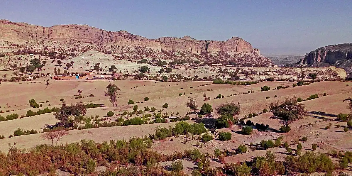
Concealed among one of the famous mountain ranges in Pakistan, Karak is an examplary district. The town might appear somewhat barren at first glance. However, it’s a treasure chest filled to the brim with natural resources like oil and gas.
Serving as the district headquarters, Karak stands at the crossroads of tradition and progress. Located 123 km from Peshawar along the main Indus Highway N-55. Home to the resilient Khattak tribe of Pashtuns, it’s the only district in Pakistan exclusively inhabited by this community.
| Karak District Overview | |
| Area | 3372 SqKms |
| Province | Khyber Pakhtunkhwa |
| Divisions | Kohat division |
| Population | 706299 (Mostly Khatak) |
| Population Density/ Sq Kms | 209.4 |
| Urban Population | 56421 |
| Rural population | 649878 |
| Elevation | 548 m (1,798 ft) |
| Language | Pashto |
| Number of Village Councils | 57 |
| Number of Neighbourhood Councils | 4 |
| Police Stations | 9 |
| Provincial Assembly Seats | 2 |
| National Assembly Seats | 1 |
Over the years, this land experienced notable demographic shifts, with its population surging from 27,893 in 1998 to 51,149 in 2017. Economically, Karrak is on the rise, witnessing rapid urbanisation and growth.
With a strategic focus on mineral processing, value addition, and hydrocarbon extraction, the district presents promising opportunities for investors. Abundant reserves of coal, gypsum, limestone, and hydrocarbons position Karrak as a key player in the economic landscape.
Historical Evolution
Korak’s historical evolution is a complex story moulded by distinct phases that have shaped its unique identity.
Pre-1940 Era
In the pre-1940 era, Karak was under the rule of the Teri Nawab, with Teri serving as both the capital and the sole Tehsil. The region comprised tappas (satrapies) like Teri, Seni, Khurram, and Barak. This historical governance structure laid the foundation for Karrak’s distinctive identity.
1940-1982: Integration with Kohat
Between 1940 and 1982, Karrak became a part of Kohat. It underwent changes in administrative structure and governance. The integration impacted the local population and reshaped the district’s identity within the larger administrative framework.
Post-1982: Emergence as a Separate District
July 1, 1982, marked a significant turning point as Karak gained autonomy, becoming an independent district. This move had lasting implications for the region’s development, allowing for more focused attention on local needs and priorities.
Demographics and Cultural Identity
Karrak’s demographic and cultural image has been heavily focused on the Khatak tribe. It stands as a captivating mosaic amidst the various cities and districts of the province. Its unique characteristics set it apart, creating a fascinating narrative that mirrors the diversity within KPK.
Demographic Landscape
Unlike many other cities and districts in KPK, Karak proudly stands as the only one inhabited solely by the Khattaks. This demographic stronghold contributes to the numerical status of this district. Additionally, it also weaves a rich tapestry of traditions, language, and a way of life unique to the Khattak community.
Cultural Richness
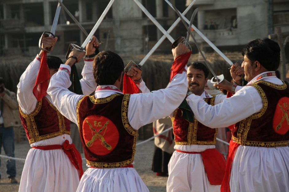
The cultural identity of Karrak is a vibrant palette, coloured by the traditions and practices of the Khattak tribe. In contrast to the cultural amalgamation found in some other regions of KPK, this district’s identity is distinctly Khattak. From festive celebrations to everyday interactions, its cultural richness unfolds through the lens of the Khattak people, leaving an indelible mark on the social fabric.
Linguistic Harmony
While Pashto stands as the predominant language in Karrak, what distinguishes it from other districts in KPK is the harmonious linguistic landscape. Despite the homogeneity in language, this place embraces diversity within its linguistic realm. This inclusive ethos sets it apart, creating an environment where linguistic differences coexist harmoniously, reflecting the district’s commitment to unity.
Comparative Analysis
In the broader context of Khyber Pakhtunkhwa, Karak’s demographic and cultural characteristics offer a unique perspective. Where famous places in Peshawar and its surrounding show a blend of cultures, Karrak is firmly rooted in Khattak tradition.
Geographical and Economic Features
The significance of Karak District lies in its multifaceted contributions to the cultural, economic, and historical fabric of the Khyber Pakhtunkhwa province in Pakistan. Home to the predominant Khattak tribe, this place embodies a rich cultural heritage, with traditions and a way of life that have left an indelible mark on its social landscape.
Economically, the district is a powerhouse, housing valuable mineral resources such as coal, gypsum, limestone, and a strategic salt mine. The historical evolution of Karrak, from pre-1940 governance to its emergence as an independent district in 1982, reflects its resilience and ability to adapt.
Beyond its economic and cultural facets, Karak’s strategic location along the Indus Highway positions it as a pivotal hub for trade and commerce. This district serves as a testament to the delicate balance between tradition and progress, making it a noteworthy player in the mosaic of Pakistan’s regional identity.
Oil and Gas Reserves
Karrak’s wealth extends beyond its geological features; it is rich in oil and gas. The exploration activities in towns like Makori, Noshpa Banda, Gurguri, and Lachi Circle have led to record-breaking daily production, contributing significantly to the national energy sector.
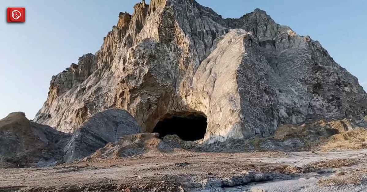
Bahadur Khel Salt Mine
Within the picturesque landscape of Karak District, the Bahadur Khel Salt Mine stands as a testament to the region’s geological wealth. Located in the heart of Karak, this salt mine holds significance not only for its economic contributions but also for the natural wonders it unveils.
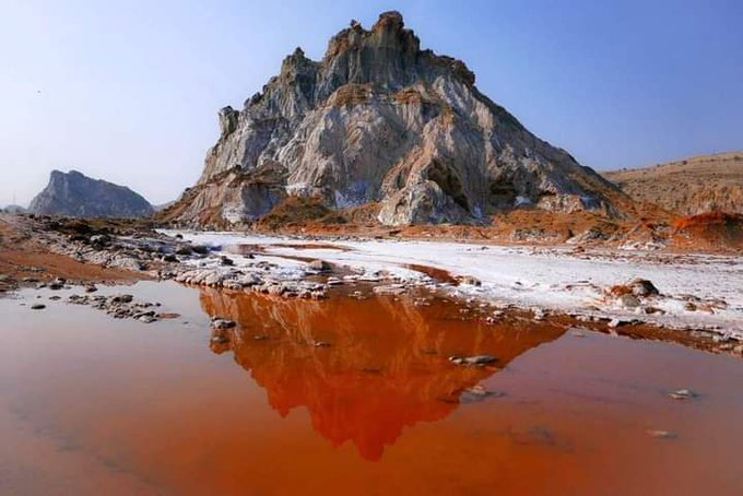
The mine is renowned for its extraction of rock salt, a valuable resource used in various industries, from construction to chemical manufacturing. As the mine echoes with the sounds of industrious activity, it also offers visitors a glimpse into the geological treasures that lie beneath the surface of Karrak.
The Bahadur Khel Salt Mine not only symbolises economic prosperity for the district but also invites exploration into the geological marvels that shape the unique character of Karrak.
Revenue Generation
The oil and gas reservoirs in Noshapa Banda generate substantial daily revenue, making Karrak a key player in the country’s economic landscape. However, this economic prosperity comes with the responsibility of sustainable resource management.
Postal Code of Karak
The seemingly mundane postal codes play a pivotal role in enhancing locational precision. Each postal code is a digital address of specific geographic coordinates of an area.
For residents, businesses, and services alike, understanding and utilising the postal code system ensures accurate mail delivery. It also facilitates efficient navigation for emergency services, and streamlines logistics for local businesses.
Here is a list of postal codes within the area.
| Karak Postal Code | |
| Area Names | Postal Codes |
| Bahadur Khel | 27410 |
| Chokara | 27300 |
| Dab Begu Khel | 27900 |
| Inzaar Banda | 27500 |
| Karak GPO | 27200 |
| Land Kamar | 27600 |
| Latamber | 27800 |
| Mitha Khel | 27100 |
| Mohabati Killa | 27210 |
| Sabir Abad | 27000 |
| Thatti Nasrati | 27400 |
| Warana | 27810 |
E-commerce Seamlessness
In the age of e-commerce, the importance of postal codes in Karrak extends beyond traditional mail. Online retailers rely on accurate postal codes to ensure that packages reach their intended destinations without a hitch.
Knowing your postal code is akin to handing a reliable roadmap to delivery services, making the e-commerce experience seamless for both sellers and buyers. The postal code, therefore, acts as a linchpin in the digital realm, connecting virtual transactions to precise physical locations in Karrak.
Community Connectivity
Beyond its logistical and digital applications, the postal code system fosters a sense of community connectivity. Knowing and using the correct postal code in Karak is not merely about efficient mail delivery; it is a shared understanding that binds residents together in a network of interconnected addresses.
In this way, postal codes become more than a series of numbers; they are the threads weaving the fabric of Karrak’s community, connecting each address to the broader tapestry of this vibrant district.
Challenges and Opportunities
Here are some opportunities and challenges this community has to face.
Development Disparities
One of the foremost challenges of this place is the uneven distribution of development resources. While the district thrives economically, some areas grapple with inadequate infrastructure and essential services. Addressing these disparities poses a pressing challenge for local authorities to ensure inclusive growth across all communities.
Socio-economic Disparities
Socio-economic disparities within Karrak persist, presenting hurdles for achieving holistic development. Education and healthcare accessibility vary across the district, underscoring the need for targeted initiatives to bridge these gaps and uplift disadvantaged communities.
Environmental Sustainability
With the district’s economic focus on mining and hydrocarbons extraction, environmental sustainability becomes paramount. Balancing economic pursuits with eco-conscious practices is a challenge, demanding the implementation of robust environmental regulations to safeguard Karak’s natural resources.
Mineral Wealth Utilisation
The vast mineral reserves, including coal, gypsum, and limestone, offer a golden opportunity for economic growth. By strategically harnessing these resources, the district can establish itself as a significant player in the national and international markets, fostering job creation and bolstering the local economy.
Hydrocarbons Exploration
The estimated reserves of hydrocarbons, particularly oil and gas, provide a substantial opportunity for Karak. Through careful exploration and collaboration with geological experts, the district can capitalise on its hydrocarbon wealth, stimulating economic growth and attracting investment in the energy sector.
Agricultural Diversification
Despite challenges, Karak’s fertile lands hold potential for agricultural diversification. Encouraging modern farming techniques, introducing cash crops, and enhancing water resource management can revitalise the agricultural sector, providing alternative livelihoods and ensuring food security.
Tourism Development
Karrak’s historical significance, coupled with its unique cultural identity, positions the district as a potential tourist destination. Leveraging its heritage and scenic landscapes, Karak can invest in tourism infrastructure, creating a niche for itself in the burgeoning tourism sector and boosting local economies.
Political Representation
In the contemporary political landscape, Karak Town stands as a key player in the democratic process of Khyber Pakhtunkhwa. Local representation is now more direct and reflective of the aspirations of Karrak’s residents. The town serves as a constituency where elected representatives actively engage in shaping policies that address the unique needs and challenges faced by the community.
Present-day political representation in Karrak is characterised by a blend of tradition and modern governance, with local leaders advocating for the socio-economic development of the town and its surrounding areas. As part of the larger democratic framework, Karrak district’s political dynamics continue to evolve, ensuring that the voices of its residents are heard in the corridors of decision-making.
Conclusion
As we delve into the intricate history, cultural nuances, and economic dynamics of Karak, it becomes evident that this district is not just a geographical entity but a living, breathing community. The challenges it faces today, from environmental concerns to social disparities, are opportunities for growth and transformation.
The future of Karrak hinges on a delicate balance between preserving its rich heritage and embracing sustainable development. It is a tapestry still in the making, with each thread contributing to a vibrant and resilient future for the people of Karrak.
Frequently Asked Questions
What is the historical significance of Karak District?
Karak District has a rich history, initially ruled by the Teri Nawab. It was a crucial part of Kohat before gaining district status in 1982, shaping its unique identity.
Which tribe predominantly inhabits Karak?
The Khattak tribe is the predominant population in Karak, contributing significantly to the district’s cultural tapestry.
How has Karak’s administrative status changed over the years?
Until 1940, Karak was under the rule of the Teri Nawab. From 1940 to 1982, it was part of Kohat before becoming a separate district on July 1, 1982.
What languages are spoken in Karak?
Pashto is the predominant language spoken in Karak, reflecting the cultural unity of the region.
What natural resources are abundant in Karak?
Karak is rich in natural resources, including extensive salt mines, gypsum deposits, and significant oil and gas reservoirs.
How does Karak contribute to the national energy sector?
Towns like Makori, Noshpa Banda, Gurguri, and Lachi Circle in Karak host oil and gas reservoirs, contributing to record-breaking daily production and playing a vital role in the national energy sector.
What environmental challenges does Karak face due to mining activities?
The economic prosperity from mining activities in Karak comes with environmental challenges, including the need to balance development with conservation.
How is Karak represented politically?
Karak is represented in various assemblies by members affiliated with different political parties, contributing to regional and national political landscapes.
What steps are being taken for sustainable development in Karak?
Sustainable development in Karak involves addressing environmental concerns, promoting inclusive growth, and investing in infrastructure and skill development to ensure a resilient future for the district.
Learn more cities in KPK like Jamrud on Graana blog.