Environment

A Complete Account of Indus River

Flowing through the stunning landscapes of South Asia, the Indus River ranks among the world’s longest rivers. It has greatly influenced the histories of what we now call India and Pakistan. The river has been an important resource for ancient civilisations that thrived in the Indus Valley.

invest with imarat

Islamabad’s emerging city centre

Learn More

This region played a role in one of the world’s earliest cultures, as evident in the ancient hymns and writings from India. The river is so important that it’s actually where the name of the country comes from.

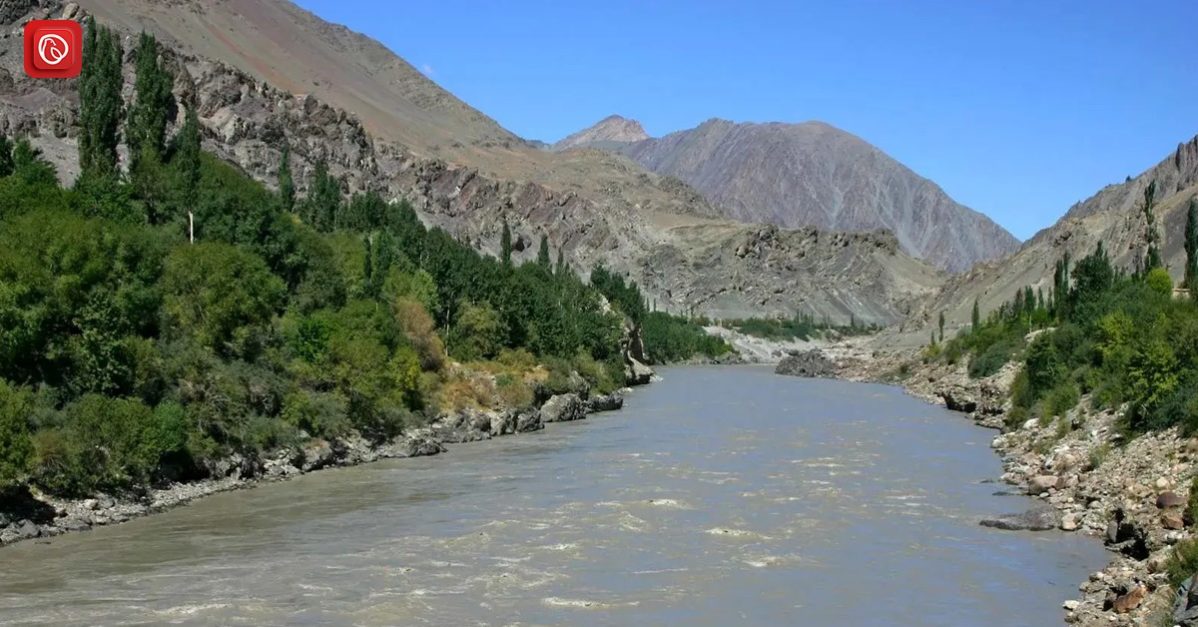
In this blog, Graana.com will take you on a journey to explore the interesting history, cultural significance, and ecological importance of the mighty Indus River, and how it has profoundly impacted the lands and communities it has supported for centuries.

Overview of Indus River

  • The Indus River, known as Sindhu in Tibetan and Sanskrit and Mehran in Sindhi, is a massive river in South Asia.
  • It ranks among the world’s longest rivers, spanning over 2,000 miles in length.
  • The river’s watershed encompasses a vast area, approximately 450,000 square miles, with about 175,000 square miles located in the Himalayas, Hindu Kush, and Karakoram Range, while the remaining portion flows through the semi-arid plains of Pakistan.
  • In terms of water flow, the Indus River carries an annual volume of around 58 cubic miles, surpassing the Nile River’s flow and being three times greater than the combined flow of the Tigris and Euphrates rivers.
  • The river’s name, “Indus,” finds its origins in the Tibetan and Sanskrit name “Sindhu.”
  • Even ancient records and hymns, such as the Rigveda composed around 1500 BCE, reference this river, and it is the source of the country’s name.

Geography & Features of the Indus River


Under the following headings, you will find the features and geography of the Indus river.

Source and Initial Flow

  • The Indus River begins its journey in southwestern Tibet, China, near Lake Mapam, at a staggering elevation of about 18,000 feet.
  • It first flows northwest for approximately 200 miles, crossing into the disputed Kashmir region at an elevation of 15,000 feet.

Tributaries and Glacial Sources

  • Near Leh, in the Indian-administered Ladakh region, the Indus welcomes its first significant tributary, the Zanskar River, on its left bank.
  • As it proceeds about 150 miles into the Pakistani-administered areas of Kashmir, it encounters another notable tributary, the Shyok River, on its right bank.
  • Glacial meltwater from the Karakoram Range, Nanga Parbat massif, and Kohistan highlands, as well as several smaller streams, contributes to the river’s flow.

Mid-course Changes and Gorges

  • The Shigar River joins from the right bank near the valley of Skardu, followed by the Gilgit River, another right-bank tributary at Bunji.
  • The Astor River, fed by the eastern slope of Nanga Parbat, becomes a left-bank tributary.
  • The Indus changes its course, passing around Nanga Parbat, through deep gorges with depths ranging from 15,000 to 17,000 feet and widths spanning 12 to 16 miles.
  • This region offers breathtaking views of the river from elevations of 4,000 to 5,000 feet.

Transition to Lowlands

  • Emerging from the highland region, the Indus transforms into a fast mountain stream, winding through Khyber Pakhtunkhwa province between the Swat River and Hazara areas until it reaches Tarbela Dam.
  • Near Attock, the Kābul River joins the Indus, and the river flows at an elevation of 2,000 feet, where the first bridge accommodates rail and road traffic.
  • The river eventually traverses the Salt Range near Kalabagh, entering the Punjab Plain.

Confluence and Significance

  • The most significant tributaries of the Indus, namely the Jhelum River, Chenab River, Sutlaj, Beas, and Ravi Rivers, join from the eastern Punjab Plain, collectively giving the region its name “Punjab,” meaning “Five Rivers.”
  • This confluence significantly enlarges the Indus, especially during the flood season, when it can expand to several miles in width.
  • As it meanders slowly across the plain in western and southern Punjab province in Pakistan, the Indus deposits silt on its bed, raising it above the level of the surrounding sandy plain.

Formation of Sindh Province & Flood Control

  • Much of Pakistan’s Sindh province has been formed by the alluvium carried and deposited by the Indus over time.
  • Although embankments have been constructed to prevent flooding, occasional breaches result in devastating floods, as seen in 1947, 1958, and 2010.

Delta Formation & Unique Geography

  • Near Tatta, the Indus divides into smaller distributaries that form a delta, ultimately joining the sea south-southeast of Karachi.
  • This delta encompasses an area of over 3,000 square miles, extending along the coast for about 130 miles.
  • The delta’s uneven surface contains a network of active and abandoned channels, with the coastal strip experiencing flooding during high tides.
  • The Indus delta is characterised by protruding distributaries and low sandy beaches, contributing to its unique and dynamic geography.

Indus River Hydrology


The Indus River system is primarily fed by snowmelt from the mountains. The flow of these rivers varies throughout the year, with the lowest water levels during December to February, a rise in spring and early summer , and floods during July to September. Sometimes, there are sudden and devastating flash floods. 

Most of the water in the Indus and its tributaries comes from the hilly upper regions of their catchment areas. This means that their flow is highest when they flow out of the foothills, and not much water is added as they move through the plains. Here, evaporation and seepage reduce the volume of water. 

However, there is some additional water due to seepage after the monsoon months. The main Indus River is at its lowest from mid-December to mid-February, starts rising slowly, and then rapidly from the end of March. The highest water levels are usually between mid-July and mid-August, followed by a gradual decrease until the start of October. 

The upper Indus carries about 26.5 cubic miles of water annually, which is slightly less than half of the total water supply in the Indus River system. The Jhelum and Chenab rivers together account for about one-fourth, and the Ravi, Beas, and Sutlej rivers make up the rest.

Over a long period of time, there is evidence that the course of the Indus River has shifted. This has been happening for at least 4,500 years since the time of the ancient Indus civilisation. 

The river used to be confined between limestone ridges in Sindh but has been shifting mainly to the west, especially in its delta region. In northern Sindh, the Indus has moved westward by about 10 to 20 miles in the last seven centuries. 

Climate of the Indus River

The climate in the Indus River region undergoes significant variations from its source to where it meets the sea. This area receives annual precipitation ranging from 5 to 20 inches. Except for the mountainous region in Pakistan, the Indus valley is located in one of the driest parts of the subcontinent. 

During the winter, the upper Indus valley experiences northwest winds that bring about 4 to 8 inches of essential rainfall, which is crucial for the successful cultivation of crops such as wheat and barley. In the upper Indus’s mountainous areas, most of the precipitation falls as snow. 

A substantial portion of the Indus River’s water supply originates from the melting snow and glaciers in the Karakoram, Hindu Kush, and Himalayan mountain ranges. The remainder of the river’s flow is attributed to the monsoon rains that occur from July to September.

The climate across the Indus valley exhibits significant diversity, ranging from the arid semi-desert conditions in Sindh and Punjab provinces to the extremely harsh high mountain climate found in regions like Kohistan, Hunza, Gilgit, Ladakh, and western Tibet. 

In the northern mountainous areas, temperatures in January typically average below freezing, while in Sindh and Punjab provinces, daytime high temperatures in July can average around 38°C. Jacobabad, located to the west of the Indus River in northern Sindh, is renowned as one of the hottest places on Earth and frequently experiences summer maximum temperatures of 49°C.

Flora of the Indus River


  • Vegetation Diversity: The flora along the Indus River varies depending on the region’s climate and human activities.
  • Desert Conditions: In the lower Indus, about 10 to 25 miles away from the river, desert conditions prevail, with sand and limited grass cover.
  • Impact of Irrigation: Irrigation by floods or canals permits some cultivation, but intensive irrigation can lead to soil salinisation.
  • Deforestation and Overgrazing: Overgrazing and timber felling for fuel have damaged natural vegetation in northern Sindh and Punjab province.
  • Historical Changes: Historical records suggest that the middle Indus region was once more wooden than it is today, with evidence from ancient accounts.
  • Reforestation Efforts: Some regions, like Thal in the Punjab area, have seen successful reforestation efforts.

Fauna of the Indus River


  • Fish Population: The Indus River is moderately rich in fish, with the hilsa being the most important edible fish.
  • Fishing Centres: Important fishing centres are located in Tatta, Kotri, and Sukkur in Sindh province.
  • Trout Fishing: Between Swat and Hazara areas, the river is known for trout fishing.
  • Fish Farming: Fish farming has become significant in the reservoirs of dams and barrages.
  • Marine Fish: Near the river’s mouth and along the coast, numerous creeks and shallow seawater areas are rich in marine fish, including pomfrets and prawns.
  • Modern Fish Harbors: Modern fish harbours, such as the one near Karachi, provide cold storage and marketing facilities.
  • Export Trade: An export trade in prawns has developed, and sea fish are marketed in different parts of Pakistan.

Frequently Asked Questions (FAQs)

Following are a few of the FAQs regarding Indus river:


What is the Indus River?

The Indus River is one of the major rivers in Pakistan, flowing through China, India, and Pakistan. It has a rich historical and geographical significance and is a lifeline for the region.


Where does the Indus River originate?

The Indus River originates in southwestern Tibet Autonomous Region, China, near Lake Mapam.


What is the length of the Indus River?

The Indus River is approximately 1,990 miles long, making it one of the longest rivers in Asia.


Which countries does the Indus River flow through?

The Indus River flows through China, India, and Pakistan. The majority of its course is within Pakistan.


What is the significance of the Indus River in ancient history?

The Indus Valley, through which the river flows, is the site of one of the world’s earliest urban civilizations, the Indus Valley Civilization (circa 3300–1300 BCE).

This was all about the Indus river. For more information like Indus Valley Civilization, visit Graana.com. 

Saleha Ali

Saleha Ali, an SEO writer at Graana.com, loves crafting engaging content. She is passionate about writing content which is both informative and creative. Besides writing, she enjoys watching thrillers.

Recent Posts

Exploring Keti Bunder

Keti Bunder was formerly a bustling port city and is currently a taluka in the…

1 hour ago

Exploring Millat Chowk: A Vibrant Hub in Faisalabad

Located in a buzzing part of lively Faisalabad, Millat Chowk is more than just a…

3 hours ago

Exploring the District of Matiari

Matiari, a district in Sindh province rich in history and culture, is well-known for its…

1 day ago

Journey Along the Indus Highway: Exploring Pakistan’s Lifeline

The Indus Highway, officially called National Highway 55 (N-55), is a 1264 km two—to four-lane…

1 day ago

Exploring Kairpur Tamewali

Khairpur Tamewali is a town located in Bahawalpur, Pakistan. Known initially as Tanori, named after…

1 day ago

Batkhela: A Hidden Treasure In Malakand Valley

Amidst the lush valleys of the Malakand region in Khyber Pakhtunkhwa, Pakistan, lies the city…

2 days ago