Source: Graana.com
The Indus Highway, officially called National Highway 55 (N-55), is a 1264 km two—to four-lane national highway that connects the port city of Karachi with the northwest city of Peshawar via Dera Ghazi Khan. It runs along the Indus River in Pakistan. The National Highway Authority of Pakistan manages and maintains the Indus Highway, which is part of the country’s network of national highways. The Kohat Tunnel is traversed by the Indus Highway.
Graana.com has discussed everything you need to know about the Indus Highway, including its history, location, climate, and much more.
The Indus Highway was first planned in 1980 as a quicker and less congested route to the busy N-5 and to promote the growth of the provinces of Khyber Pakhtunkhwa in the east and Sindh in the west. In Kotri, work started in 1981 and was finished in Peshawar in 1997. Principal cities that it connects to:
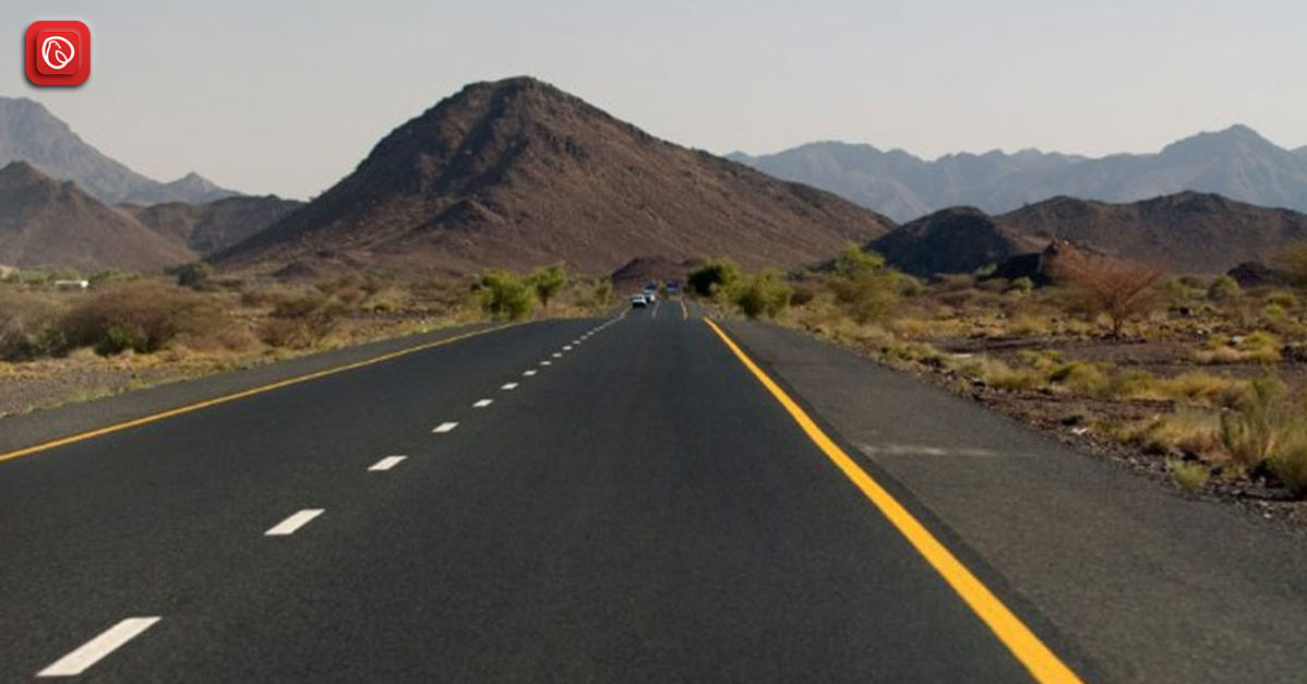
The Indus Highway stretches across the heart of Pakistan, traversing through the provinces of Punjab, Khyber Pakhtunkhwa, and Sindh. It begins near the city of Peshawar in the northwest, running southward parallel to the mighty Indus River, which serves as a geographical and historical lifeline for the region.
The highway passes through major cities and towns such as Nowshera, Dera Ismail Khan, and Sukkur, before culminating near the bustling metropolis of Karachi, Pakistan’s largest city and financial hub, situated on the Arabian Sea coast.
This extensive route covers a diverse range of landscapes, from the rugged mountains and valleys of the north to the fertile plains and riverbanks of the south, making it a crucial artery for transportation and connectivity across the length and breadth of the country.
The climate along the Indus Highway varies significantly depending on the region and elevation. In the northern stretches near Peshawar and Nowshera, the climate is typically arid to semi-arid, with hot summers and relatively mild winters. These areas experience low precipitation levels and are characterized by dry, dusty conditions for much of the year.
As the highway progresses southward towards Dera Ismail Khan and Sukkur, the climate transitions to a hotter and more arid environment. Summers in these regions can be extremely hot, with temperatures soaring well above 40°C (104°F) during the peak months. Winters are milder but still relatively warm compared to northern climates.
In the southernmost parts of the highway near Karachi and the coastal areas of Sindh, the climate becomes more influenced by the proximity to the Arabian Sea. Here, summers are hot and humid, with temperatures moderated by sea breezes, while winters are mild and pleasant. The coastal regions also experience higher precipitation levels than inland areas, particularly during the monsoon season from June to September.
Overall, the climate along the Indus Highway ranges from arid to semi-arid in the north to hot and humid in the south, with variations in temperature, precipitation, and humidity depending on the location and season. These diverse climatic conditions present challenges and opportunities for travellers and residents alike along the highway’s length.
The geography along the Indus Highway is incredibly diverse, reflecting the varied landscapes that characterize Pakistan’s topography. The highway traverses through regions ranging from rugged mountain ranges to fertile plains, offering breathtaking views and unique geographical features along the way.
In the northern parts of the highway, particularly near Peshawar and Nowshera, the terrain is dominated by the majestic Hindu Kush peaks and the foothills of the Himalayas. These mountainous regions are characterized by steep slopes, deep valleys, and winding rivers, creating a challenging yet scenic environment for travellers.
As the highway progresses southward, it passes through the vast, arid plains of Punjab and Khyber Pakhtunkhwa, where the landscape transitions to expansive fields of wheat, cotton, and sugarcane interspersed with small villages and towns. The fertile plains along the banks of the Indus River are vital for agriculture, serving as Pakistan’s breadbasket and supporting a significant portion of the country’s population.
Further south, as the highway approaches Sukkur and Hyderabad, it traverses through the arid desert regions of Sindh, where the terrain is characterized by sandy dunes, sparse vegetation, and occasional oasis-like settlements. The flat, barren landscape of the Thar Desert extends along the eastern fringes of the highway, offering a stark contrast to the lush greenery of the northern regions.
Finally, the highway culminates near Karachi, Pakistan’s largest city and principal port, situated along the Arabian Sea coast. Here, the landscape transitions once again, with sandy beaches, bustling urban centres, and bustling ports dotting the coastline.
The Indus Highway, like many infrastructure projects, faces a variety of challenges that impact its functionality, safety, and effectiveness. Here are some key challenges:
The diverse geography along the route presents significant challenges, especially in regions with rugged terrain, steep slopes, and unpredictable weather conditions. Heavy rains, snowfall, landslides, and floods can all threaten the stability of the highway, leading to road closures, transportation disruptions, and safety hazards for travellers.
Maintaining a highway of such length and diversity is a formidable task. Regular maintenance is essential to maintaining the road surface, repairing damage caused by natural disasters or heavy traffic, and ensuring motorists’ safety. However, limited resources, inadequate funding, and bureaucratic inefficiencies can hinder the timely execution of maintenance activities, leading to deteriorating road conditions and increased risks for travellers.
The Indus Highway serves as a vital artery for transportation and commerce, catering to a large volume of vehicular traffic on a daily basis. Traffic congestion, especially in urban areas and major intersections, can lead to delays, frustration, and safety hazards for motorists. Addressing traffic congestion requires comprehensive planning, investment in infrastructure upgrades, and implementation of traffic management strategies to improve the flow of vehicles along the highway.
Safety is a paramount concern on any highway, and the Indus Highway is no exception. Accidents, collisions, and fatalities are not uncommon. This is particularly due to factors such as reckless driving and limited enforcement of traffic regulations. Enhancing safety along the highway requires a multi-faceted approach, including investments in road infrastructure, public awareness campaigns, and enforcement of traffic laws to minimize risks and improve overall road safety.
The construction and operation of the Indus Highway can have significant environmental consequences, including habitat destruction, air and water pollution, and disruption of natural ecosystems. Balancing the need for infrastructure development with environmental conservation requires careful planning, environmental assessments, and mitigation measures to minimize negative environmental impacts and promote sustainable practices.
Here are some tourist spots located near the Indus Highway:
Located near Mardan in Khyber Pakhtunkhwa, Takht-i-Bahi is an ancient Buddhist monastery complex dating back to the 1st century CE. It is a UNESCO World Heritage Site and offers visitors a glimpse into Pakistan’s rich Buddhist heritage.
Rohtas Fort is a historical fortress built by the Afghan king Sher Shah Suri in the 16th century. It is situated near Jhelum in Punjab. The fort’s impressive architecture and strategic location make it a popular destination for history enthusiasts and photographers.
Located near Chakwal in Punjab, the Katas Raj Temples are a complex of Hindu temples dedicated to Lord Shiva. The temples are renowned for their architectural beauty, sacred ponds, and religious significance, attracting pilgrims and tourists from all over the world.
Mohenjo-Daro is one of the world’s oldest and most well-preserved urban settlements dating back to the Indus Valley Civilization. It is present near Larkana in Sindh. Visitors can explore the ancient ruins, including the Great Bath, the Granary, and the Dancing Girl statue, and learn about this fascinating ancient civilization.
Chaukhandi Tombs are a collection of intricately carved sandstone graves dating back to the 15th to 18th centuries. The tombs are famous for their unique architectural style. Moreover, people consider them as important heritage sites in Pakistan.
Also known as the Great Wall of Sindh, Ranikot Fort is one of the largest forts in the world. It is located near Jamshoro in Sindh. The fort’s massive walls and picturesque surroundings make it a popular destination for hikers, history buffs, and adventurers.
Following are the most common questions and their answers for Indus Highway.
The Indus Highway is a major road artery in Pakistan. The highway stretches from the north near Peshawar to the south, ending near Karachi. It plays a crucial role in connecting various regions of the country and facilitating the movement of goods and people.
The exact length of the Indus Highway is approximately 1,200 kilometres (745 miles), making it one of the longest highways in Pakistan.
The Indus Highway passes through several major cities and towns. These include Peshawar, Nowshera, Dera Ismail Khan, Sukkur, Hyderabad, and Karachi, among others.
The Indus Highway is important for several reasons. This includes its role in facilitating trade and commerce and connecting rural and urban areas. Furthermore, it promotes tourism and supports economic development across the country.
Challenges faced by the Indus Highway include terrain and weather-related issues, maintenance and upkeep, traffic congestion, safety concerns, and environmental impacts.
Yes, certain sections of the Indus Highway are prone to landslides and floods, especially during the monsoon season. These natural phenomena can disrupt transportation and pose safety hazards for travellers.
Yes, there are ongoing efforts to upgrade and improve the Indus Highway infrastructure. These include widening projects, the construction of bridges and tunnels, and enhancements to road quality and safety features.
Measures to ensure the safety of motorists on the Indus Highway include enforcement of traffic laws, installation of road signs and safety barriers, implementation of speed limits, and public awareness campaigns.
As of now, the Indus Highway is primarily toll-free. However, there may be certain sections or newly constructed segments that require toll payments. It’s essential to check for updates on toll regulations before travelling.
Yes, tourists can explore various attractions along the Indus Highway, including historical sites, natural landmarks, and cultural destinations. Popular tourist spots include archaeological sites like Mohenjo-Daro, scenic landscapes in Khyber Pakhtunkhwa, and cultural landmarks in Sindh and Punjab.
For more related information, visit Graana Blog.
Islamabad: The chairman of the Capital Development Authority (CDA) and Chief Commissioner Islamabad, Muhammad Ali…
Peshawar: The Khyber Pakhtunkhwa government is exploring plans to construct a 31-kilometre outer ring road…
Islamabad: The National Highway Authority (NHA) has spent more than half of its development budget…
Karachi: A high-level meeting chaired by Sindh Minister for Local Government Syed Nasir Hussain Shah…
Riyadh: Saudi Real Estate Co. (Al Akaria) has signed a long-term lease agreement with Amsa…
Rawalpindi: The divisional administration has begun acquiring land for the Rs5 billion Thalian Interchange, a…
Welcome to Graana Blog - Pakistan’s Smartest Property Portal!
For more than a decade our intention has been to revolutionise the real estate industry in Pakistan. The same belief drove the vision of our real estate team, Graana where quality beats quantity.
We have introduced an extremely transparent and purposeful portal where we will help you buy, rent or sell your property. A place where you can sit back relax and let us market your projects and listings. We believe we have set new standards for the future of real estate in Pakistan by providing the smartest property portal.


