Pakistan is an agricultural country, and its economy heavily relies on irrigation for crop production. Therefore, water management plays a vital role in Pakistan’s agriculture and the economy at large. Barrages are built to manage the country’s water resources. Pakistan has several barrages, each serving different purposes, such as flood control and irrigation.
In this blog, Graana.com gives an overview of some of the major barrages in Pakistan.
The Basics – What is a Barrage?
A hydraulic structure or dam known as a barrage is built across a river or tidal estuary to control the flow of water. Its main objectives are to control water flow and level, manage flooding, and store water for various uses, such as irrigation, water supply, and hydroelectric power production.
Typically, barricades have many gates or sluices that can be opened or closed as necessary. By controlling these gates, authorities can control the release of water downstream or impound water for storage behind the barrage. When water flow is held, it can release water during dry spells to support agricultural and other requirements or prevent floods during excessive rainfall.
By maintaining a constant water level in rivers and estuaries, barrages can aid in navigation, transit, flood control, and water storage. They are crucial infrastructure for controlling water supplies in many parts of the world.
Importance of Barrages in Pakistan
Barrages in Pakistan play a crucial role in supporting the nation’s agriculture-dependent economy. With a primary focus on irrigation, these hydraulic structures effectively manage water resources, providing a consistent water supply for crops. Additionally, barrages contribute significantly to flood control, protecting communities and infrastructure during excessive rainfall.
Many barrages in Pakistan are equipped with hydropower stations, generating sustainable energy. The controlled release and storage of water by barrages ensure a reliable water supply during dry periods. Moreover, these structures aid navigation, promoting economic activities through regulated waterways.
Economically, barrages are vital, sustaining the agricultural sector, a key component of Pakistan’s economy. The energy generated from hydropower stations enhances the country’s overall energy security. Furthermore, barrages support environmental conservation efforts by maintaining stable water levels and preventing harmful fluctuations in ecosystems.
Barrages in Pakistan
The following table provides details of all the barrages in Pakistan, including the river it is built upon, year of completion, and length.
| Barrage | River | Year of Completion | Length |
| Chashma Barrage | Indus | 1971 | 1,084 m (3,556 ft) |
| Ghazi Brotha Barrage | Indus | 2004 | 51.90 km |
| Jinnah Barrage Pakistan | Indus | 1946 | 1,152 m (3,780 ft) |
| Rasul Barrage | Jhelum | 1968 | 975 m (3,201 ft) |
| Taunsa Barrage | Indus | 1958 | 1,325 m (4,346 ft) |
| Trimmu Barrage | Chenab | 1939 | 922 m (3025 ft) |
| Guddu Barrage | Indus | 1962 | 1,355 m (4446 ft) |
| Kotri Barrage | Indus | 1955 | 1,600 m (5,200 ft) |
| Sukkur Barrage | Indus | 1932 | Approximately 2 km (1 mi) |
Chashma Barrage
Chashma Barrage, in the Mianwali District of Punjab, is located on the Indus River, 304 km northwest of Lahore and 56 km downstream of Jinnah Barrage Pakistan. The construction contract for Chashma Barrage was awarded to the French Consortium Société Dumez and Société Borie on February 10, 1967. It was completed on March 25, 1971, at a total cost of Rs. 399 million. However, power generation did not begin until 2001.
Chashma Barrage’s power station has a total installed capacity of 184 MW, which comes from eight Kaplan-type bulb turbine units, with each unit having a capacity of 23 MW. These turbines, manufactured by Fuji, were installed for the first time in Pakistan.
The first unit began operating in January 2001, and the final commissioning of all eight units was completed by July 2001. Chashma Barrage serves multiple purposes, such as irrigation, flood control, and power generation. Additionally, there is a Ramsar site situated close to the location.
Ghazi-Barotha Barrage
The Ghazi-Barotha Barrage, located in Punjab and connected to the Indus River, is a 1,450 MW run-of-the-river hydropower project situated about 10 km (6.2 mi) west of Attock, and east of Swabi and Haripur districts in Khyber Pakhtunkhwa. It was built in 1995 and comprises five generators, each capable of producing a maximum power generation capacity of 290 MW.
On August 19, 2003, former president General Pervez Musharraf inaugurated a plant and the first two of its five generators, Unit 1 and Unit 2. The project was finished in December 2004, after the commissioning of the last generator on April 6, 2004.
The project received funding from various sources, including Pakistan’s Water and Power Development Authority (WAPDA), the World Bank, Asian Development Bank, Japan Bank for International Cooperation, Kreditanstalt für Wiederaufbau, European Investment Bank, and Islamic Development Bank, with a total cost of $2.1 billion.
A total of 1,600 cubic metres per second of water is redirected from the Indus River near Ghazi, Khyber Pakhtunkhwa, which is approximately 7 km downstream from Tarbela Dam. The diverted water then flows through a concrete power channel that is 100 metres wide and 9 metres deep, stretching for 52 km until it reaches the village of Barotha, where the power complex is situated.
Over a distance of 63 km between Ghazi and Barotha, the Indus River has a 76-metre incline. Once it flows through the powerhouse, the water is released back into the Indus River. In addition to these primary structures, there are also transmission lines that span 225 km.
Located 7 km downstream of Tarbela Dam, the barrage has a pond that regulates the daily discharge from Tarbela. It diverts the flow into the power channel and adds compensation water during low-flow seasons.
Jinnah Barrage
The Jinnah Barrage is located near Kalabagh. It is part of the Thal Project. The project helps irrigate an area of 770,000 hectares (1,900,000 acres). This area is in the Sindh Sagar Doab, located to the east of the Indus River. The planning for the barrage dates back to the 19th century. However, the final plans were made in 1919, and construction took place from 1939 to 1946.
The Jinnah Barrage diverts an average of 283 cubic metres per second (10,000 cubic feet per second) of water into the 51.5 km (32.0 miles)-long Thal Canal, which serves areas in Bhakkar, Khushab, Layyah, Mianwali, and Muzaffargarh Districts.
The canal has an additional 3,362 km (2,089 miles) of canal branches and distributors. The barrage spans 1,152 metres (3,780 feet) over the river and has a maximum flood height of 8.5 metres (28 feet). It can discharge up to 27,000 cubic metres per second (950,000 cubic feet per second) downstream with 42 spillway gates, each of which is 18.2 metres (60 feet) wide.
A hydroelectric power station with a capacity of 96 MW was constructed on the right bank. It consists of four 12 MW pit turbine generators. The construction took place between 2006 and 2012. In June 2012, a rehabilitation project for the barrage began.
As part of this project, a downstream weir measuring 244 meters (801 feet) is being built. The purpose of the weir is to dissipate energy from the upstream spillway. Additionally, new guide banks will be constructed, existing ones will be repaired, and the upstream railway bridge will be rehabilitated.
Rasul Barrage
The Rasul Barrage is located on the River Jehlum, between Jhelum District and Mandi Bahauddin District in Punjab. It is situated 72 km downstream of the Mangla Dam.
The current Rasul Barrage was constructed in 1968, and the old barrage built by the British has been dismantled. The Punjab Irrigation Department’s Sargodha Zone is responsible for operating the barrage, which is used to control water flow in the River Jhelum for irrigation and flood control purposes.
The Rasul Barrage has a discharge capacity of 24,070 cubic metres per second. Water from the barrage is diverted to the Chenab River at Qadirabad through the Rasul-Qadirabad link canal and is ultimately transferred to the Sulemanki Barrage on the Sutlej River. The Rasul-Qadirabad link canal has the second-largest water discharge capacity after the Chashma-Jhelum link canal.
The Rasul-Qadirabad link canal has a discharge capacity of 538 m³/s. The Chashma-Jhelum link canal has a higher capacity of 615 m³/s. The Lower Jhelum Canal starts at the Rasul Barrage and has a discharge capacity of 5280 cusecs. It provides irrigation for Mandi Bahauddin and Sargodha districts. The canal covers a culturable command area of 1.45 million acres.
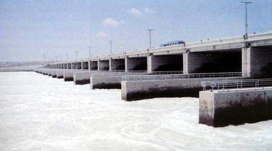
Taunsa Barrage
The Head Taunsa Barrage is a structure located in the Taunsa district of Dera Ghazi Khan Division, Punjab, about 20 km southeast of Taunsa Sharif and 16 km from district Kot Addu. It is utilised for managing water flow in the Indus River to support irrigation and flood control in the region. The site was recognised as a Ramsar site on 22 March 1996.
It controls water flow for irrigation and flood control purposes. It serves an area of 2.351 million acres (951,400 hectares). The barrage diverts flows from the Indus River to the Chenab River. It does this through the Taunsa-Panjnad Link Canal. It also serves as a crossing for utilities such as a road bridge, a railway bridge, pipelines, telephone lines, and transmission lines.
Trimmu Barrage (Head Trimoo)
Trimmu Barrage ( (تریمو بیراج) is a structure on the River Chenab located in the Jhang District of Punjab, downstream of the point where the River Jhelum meets the River Chenab. It is situated around 25 km from the city of Jhang and near the city of Atharan Hazari. It was constructed as one of the seven link canals under the Indus Water Plan of Pakistan.
The primary purpose of Trimmu Barrage is to manage the water flow in the River Chenab for the objectives of flood control and irrigation. It was originally built by English engineers between 1937 and 1939. It was primarily constructed as a flood control mechanism to protect the city of Jhang.
The barrage has undergone several upgrades over the years, including the construction of new gates and the maintenance of previous ones. The arched grid iron’s bridge section is integrated with several protective bands. LTV traffic was allowed at specific hours while HTV traffic was completely banned until the completion of the barrage on 30 June 2020. Currently, the traffic is open for both HTV and LTV. The head has been reconstructed, and new bridges have been built on the river.
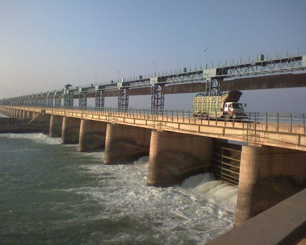
Guddu Barrage
Guddu Barrage is located near Kashmore in Sindh and was founded by former president Iskander Mirza on February 2, 1957. The barrage was completed in 1962 at a cost of 474.8 million rupees, and it was inaugurated by Field Marshal Ayub Khan in the same year.
The main purpose of Guddu Barrage is to manage water flow in the Indus River for flood control and irrigation. Guddu Barrage is a weir-type barrage with a navigation lock and 64 bays, each 60 feet wide. It has a maximum flood level height of 26 feet and a discharge capacity of 1.2 million cubic feet per second.
The barrage serves to control water flow in the River Indus. This irrigates 2.9 million acres of agricultural land in Sindh and Balochistan through several feeder canals.
Kotri Barrage
Kotri Barrage, alternatively named Ghulam Muhammad Barrage, is located on the Indus River in Sindh, between Jamshoro and Hyderabad. It was inaugurated by Ghulam Muhammad in 1955 and is primarily used for controlling water flow in the Indus for irrigation and flood control purposes.
With a maximum flood level height of 13.1 metres (43.1 ft) and a discharge capacity of 24,800 cubic metres per second (875,000 cu ft/s), the barrage consists of 44 bays, each 18 metres (60 ft) wide. It provides water to Fulleli, Pinyari, and Kalri Baghar Canals for irrigation and flood control purposes.
Sukkur Barrage
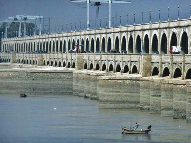
The Sukkur Barrage, formerly known as Lloyd Barrage, is located near the city of Sukkur in Sindh. The British Raj built it from 1923 to 1932. It is the largest irrigation network of its kind globally and irrigates nearly all parts of the province.
The barrage stretches from Sukkur district in the north to Mirpurkhas/Tharparkar and Hyderabad districts in the south. It is around 500 kilometres (300 miles) northeast of Karachi. The barrage is located 5 kilometres (3 miles) below the railway bridge, known as the Sukkur Gorge. It has significantly improved the water supply for existing cultivated areas in Sindh.
For more information, visit Graana.com.
FAQs
1. How many barrages are there in Pakistan?
Pakistan has 19 barrages; the exact number may change due to construction and development projects. There are 19 significant barrages in Pakistan, including Sukkur Barrage, Guddu Barrage, Kotri Barrage, and Taunsa Barrage.
2. What is the major barrage in Pakistan?
The Sukkur Barrage is often considered one of the major barrages in Pakistan. It is a significant hydraulic structure built on the Indus River and is vital in regulating water flow for irrigation and flood control in the region.
3. Which is the old barrage of Pakistan?
One of the oldest barrages in Pakistan is the Sukkur Barrage, which was completed in its initial form in 1932. It has since undergone upgrades and renovations to improve its functionality and capacity.